
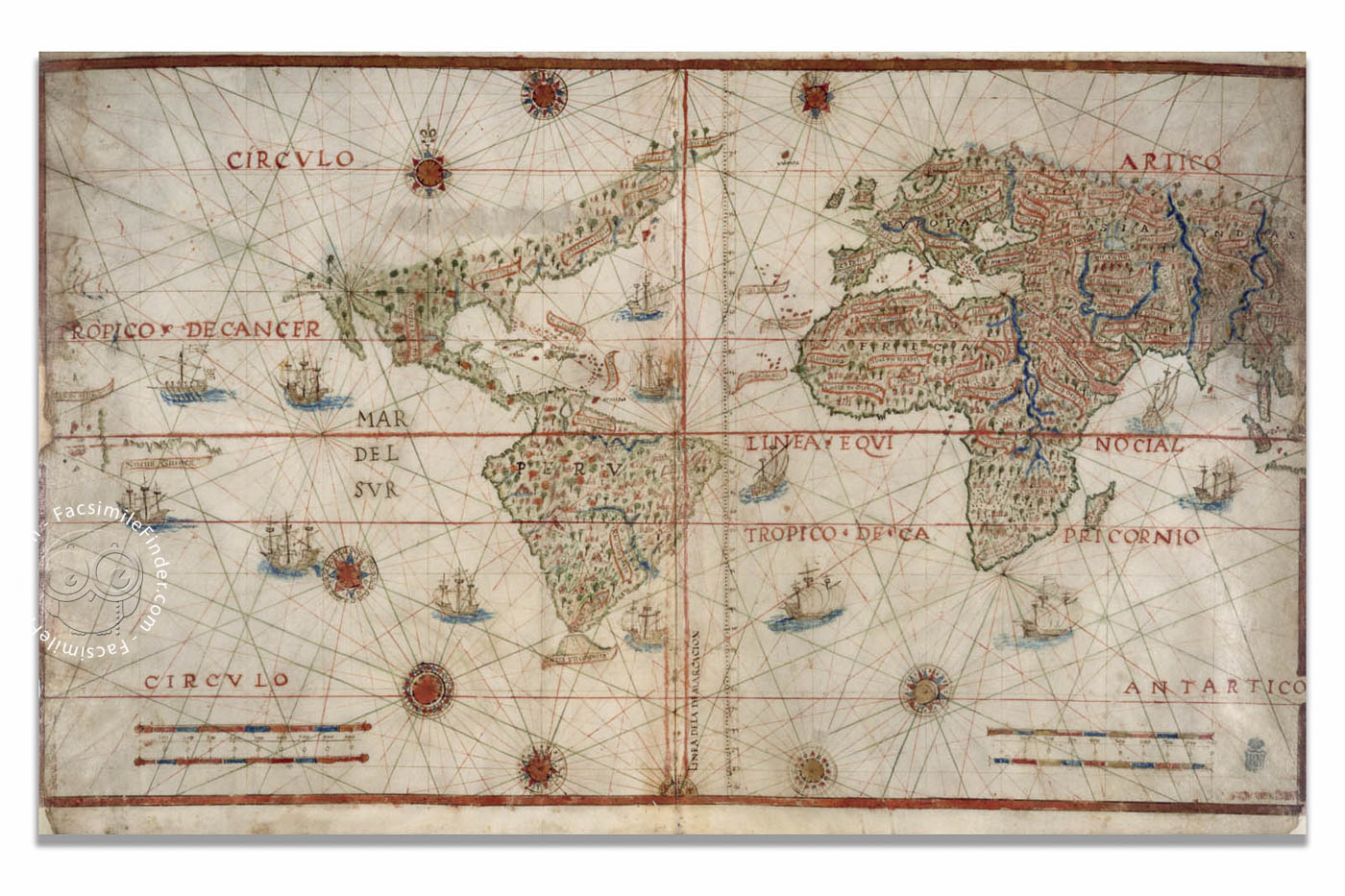

Produced by one of the most important cosmographers of the fifteenth century, the Suma de Cosmographia is an outstanding example of Renaissance cartography and geography. It was made for educational use, specifically the instruction of a prince, rather than just an esthetic or artistic motive. Nevertheless, its artistic value and its importance in the history of cartography are undeniable, and the world map shows a very accurate representation of several parts of the world known to Europeans at the beginning of the sixteenth century.
The author of this map, Pedro de Medina (1493-1567) was the most successful scientific writer of sixteenth-century Spain, as well as a renowned cosmographer, cartographer, and mathematician. He worked as an examiner of the pilots and officials who were being instructed to sail the Atlantic on the way to the New World, and some of the most important geographical and cartographical works of the sixteenth century were created by him.
A Reflection of Sixteenth-Century Geographical Knowledge
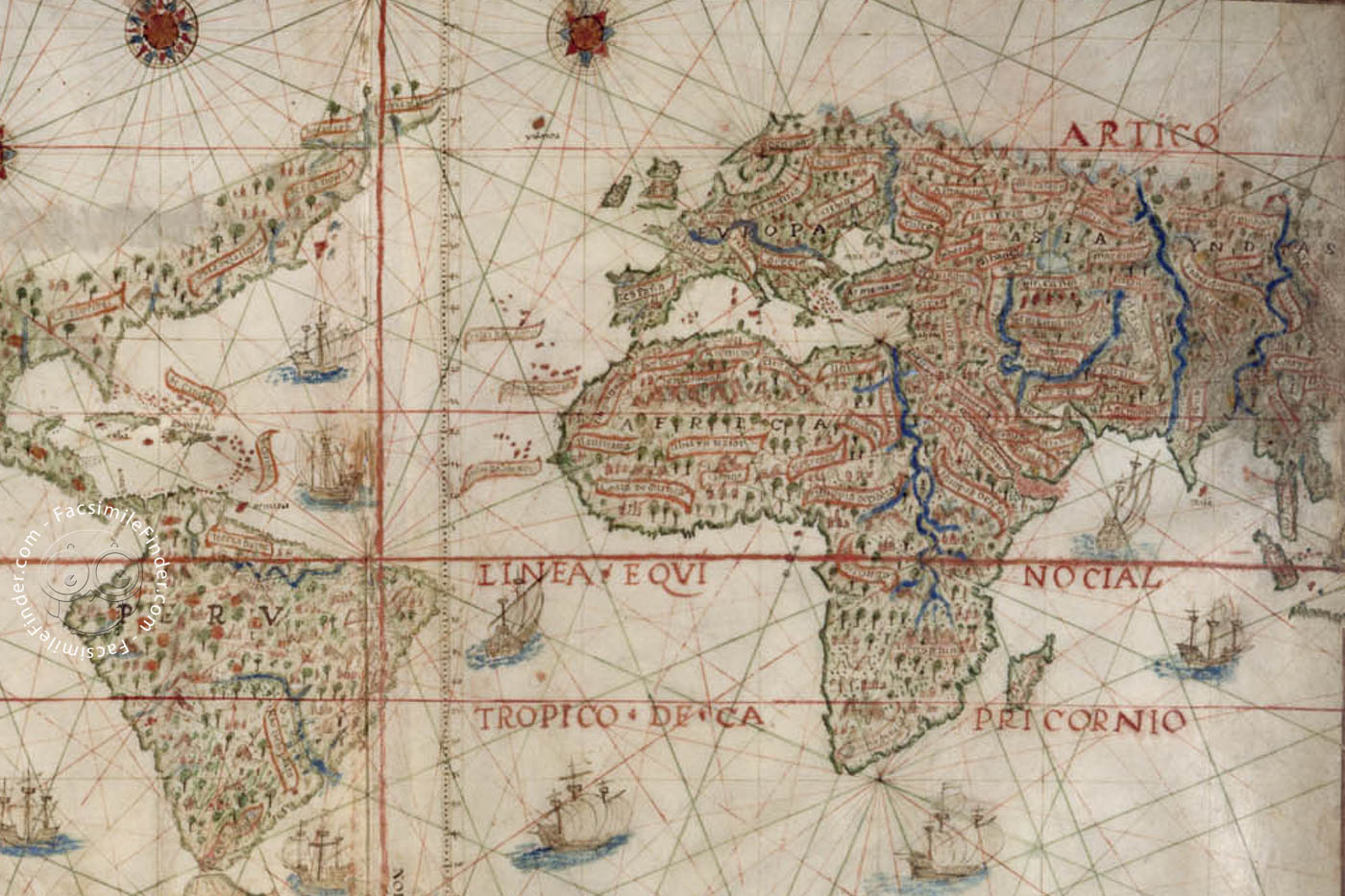
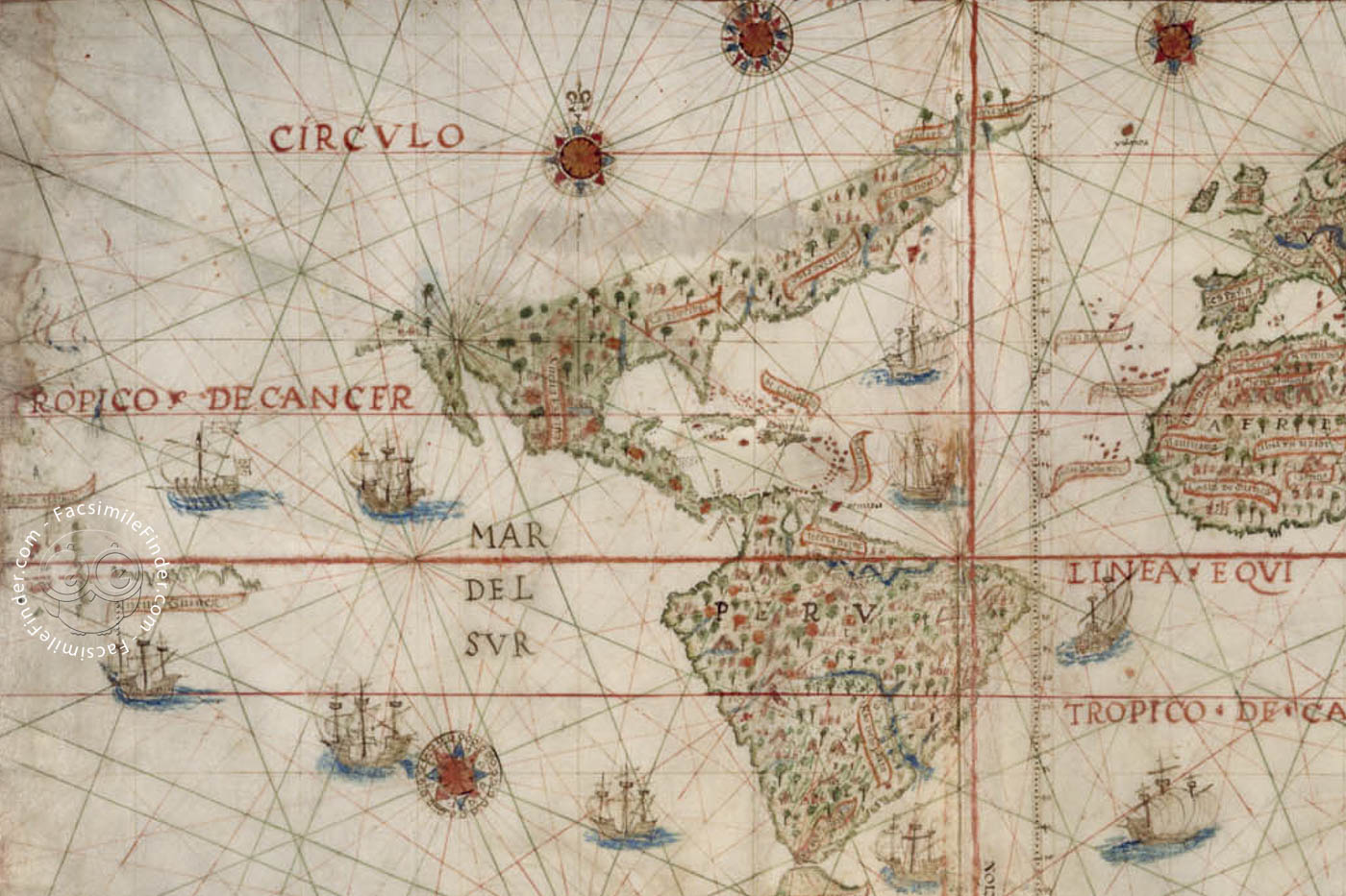
This manuscript map is drawn in fols. 2v-3r of Pedro de Medina’s Suma de Cosmographia, which he made in the mid-sixteenth century. It measures 82 x 59 cm, and is colored with ink and oil paint on parchment. The continents are prominently filled with decorative elements, such as trees, rivers, and abundant cartouches with the names of the different countries and regions.
The still unknown areas, like most of North America, are blank, and the southern edge of the New World is still marked as Tierra Yncognita (unknown land). Both the seas and the unknown regions are filled with ships, compass roses, and inscriptions, as an example of the attempt of the cartographer to avoid blank spaces, which is a common feature of historical maps.
De Medina gives special importance to the vertical line running through eastern south America, which represents the demarcation of the newly discovered lands between Portugal and Castille according to the Treaty of Tordesillas, signed by both kingdoms in 1494. He places the Moluccas, the Spice Islands, at the western edge of the map, in the Spanish hemisphere, and some of the ships trace the route through the Strait of Magellan across the Pacific to the Moluccas.
Thus, Pedro de Medina’s world map is a very interesting reflection of not only geographic knowledge but also politics and economics in sixteenth-century Spain.
Suma de Cosmographia. A Milestone in Early Modern Spanish Geography
In the years following the first voyages to the New World, the complexity of managing Castille’s overseas affairs demanded the creation of an official institution to handle it. Thus in 1503 the Crown of Castille established the Casa de la Contratación de las Indias ("House of Trade of the Indies") in Seville. This institution instructed the officials and pilots to navigate to the Indies, providing them with deep theoretical knowledge.
Given the difficulty of getting sufficient candidates to become pilots, a series of works and treatises were written by the experts and professors of the Casa de la Contratación to develop a system of “distance learning”. One of the most successful authors was Pedro de Medina, who was not technically a part of that institution, but worked in its context in Seville.
Not much is known about De Medina’s life; he belonged to the environment of the duchy of Medina Sidonia, and worked as a cosmographer and cartographer. He wrote some of the most important treatises of sixteenth-century Spanish cosmographical and nautical science, such as Libro de Cosmografía ("Book of Cosmography", 1538) and El arte de navegar ("The Art of Sailing", 1545), which had an enormous success and was translated to several European languages, a testament to its unique nature.
Nevertheless, the most beautiful of Medina's works is Suma de Cosmographia, written in the mid-sixteenth century, and intended to be read by a prince or a king, i.e. by a non-specialist reader. The manuscript contains several beautiful astronomical figures and information, and the world map on fols. 2v-3r is an outstanding image of the world known to Europeans in the first decades after the discovery of the Americas.
We have 1 facsimile edition of the manuscript "Suma de Cosmografía de Pedro de Medina": Suma de cosmografía de Pedro de Medina facsimile edition, published by Ediciones Grial, 1999
Request Info / Price