


These three maps of areas of the captaincy-general (or kingdom) of Guatemala were created in the eighteenth century, probably in the Americas by Spanish colonists. They are now housed in the Archivo General de Indias in Seville. They provide important witnesses to the concerns of the Spanish colonizers in early modern Central America at a time when the interior of New Spain was of interest to Europeans. They are executed in ink and watercolor on large sheets of paper. The largest and most colorful of the three features a palette dominated by blue, red, and green.
All three maps include the Caribbean coast, but—unlike earlier nautical maps—the focus is on the tributary rivers and interior features, although different aspects of the interior are plotted and pictured in each.
The Province of Nicaragua
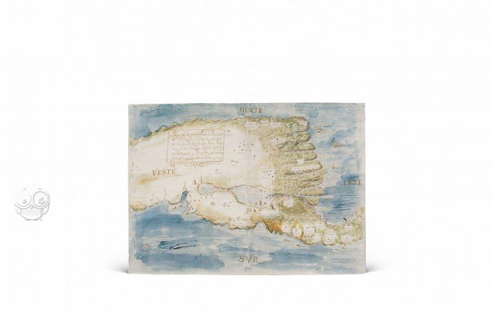
MP-Guatemala 17, dating from 1716, was perhaps made at the behest of Sebastián de Arancibia y Sasi, eventual colonial governor of the province of Nicaragua. The map's visual appeal lies in the brilliant blue of the oceans. It maps the Atlantic and Pacific coasts of the province and shows the placement of the towns of the interior. The cardinal points of the compass are identified.
The most prominent single feature is the castle of the Immaculate Conception on the south bank of Rio San Juan, understood—as implied by the map's title—to be an important bulwark against Zambo (people of mixed African and indigenous American origin) and English enemies of the Spanish.
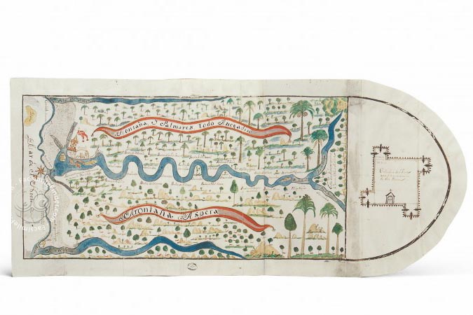
The Course of the Río Matina
MP-Guatemala 23 of 1738 is a very large map at 36.5 × 84.7 cm. It shows the course of Rio Matina and its mouth at the Caribbean, the "mar del Norte" at the map's left edge. A compass rose, with north indicated by a fleur-de-lis, provides orientation. Mountains and palm groves flank the river valley and extend to Rio Moín in the south (at the top of the sheet) and Rio Pacuare in the north (at the map's bottom edge).
Fictive red-colored ribbons warn of flooded palm groves south of the Matina and rough mountains north of the river. The plan of a fort to be built at the mouth of the Matina is shown in the semicircle at the right and its intended location by a bird's-eye view representation at the left.
The Region of Talamanca
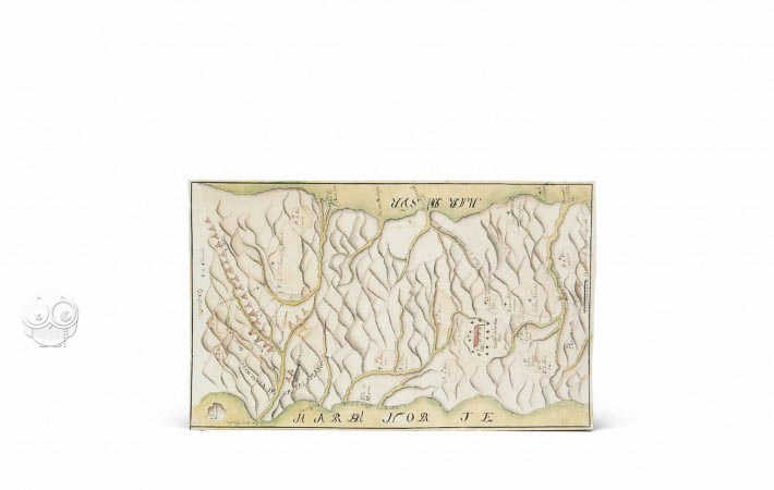
MP-Guatemala 242, dating from 1781, is a topographical map of the Talamanca region of the captaincy-general of Guatemala. Orientation is provided by the label Orientale (east) at the top, and a scale is offered at the bottom. Although the emphasis is on the contour of the land and the course of rivers, human interventions are indicated in the mapping of the extent of Spanish towns and cities (mostly toward the west) and the placement of indigenous settlements (in the east). A bridge over Rio Grande de Tárcoles is pictured in bird's-eye-view near the bottom of the sheet.
A Centralized Collection
The Archivo General de Indias in Seville was founded in 1785 at the behest of King Charles III of Spain to bring together the dispersed documents, maps, and drawings relating to the Spanish overseas territories together.
We have 1 facsimile edition of the manuscript "Maps of the Captaincy-General of Guatemala": Mapa de Costa Rica facsimile edition, published by Testimonio Compañía Editorial, 2001
Request Info / Price