

This manuscript atlas, produced between 1582 and 1584, is a very interesting work by the Greek cartographer Antonio Millo, born on the island of Milos in the early sixteenth century and active ca. 1557–1590. It depicts the known world at the time in a very accurate way. Full of graphic information, this atlas shows the knowledge of the world in the late sixteenth century.
Antonio Millo developed most of his career in Italy, and was one of the most important cartographers and cosmographers of the Republic of Venice in the second half of the sixteenth century. He was the author of several works, including atlases, portolan charts, and isolarii (books containing texts and maps about islands).
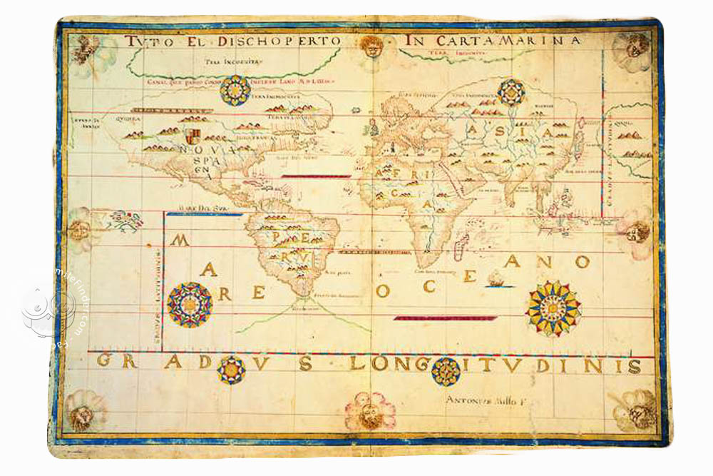
A Great Cartographic Work
This atlas is made on parchment, and measures 102 x 71 cm. It contains twenty-three maps, specifically twelve nautical charts, and eleven topographical maps, creating a very detailed graphic depiction of the known world.
In the maps, we can see abundant graphic information, such as flags and banners that show the sovereignty of the different kingdoms, following the tradition of early modern nautical charts. Both the coastlines and the inlands of the continents and countries are accurately drawn, and most of the maps contain very elaborate wind roses, a typical decorative element of early modern cartography.
The maps contained in the atlas are as follows: world map (ff. 1v-2r); Northern Atlantic (ff.3v-4r); South Atlantic (ff. 3v-5r); Central Pacific (ff. 5v-6r); Northern Pacific (ff. 6v-7r); Indian Ocean (ff. 7v-8r); Mediterranean and Western Europe (ff. 8v-9r); Western Mediterranean (ff. 9v-10r); Southern Mediterranean (ff. 10v-11r); Adriatic Sea (ff. 11v-12r); Greece, Western Asia and Southern Italy (ff. 12v-13r); Eastern Mediterranean (ff. 13v-14r); Black Sea (ff. 14v-15r); Spain (ff. 15v-16r); France (ff. 16v-17r); British Isles including Ireland (ff. 17v-18r); Flanders (ff. 18v-19r); Scandinavia (ff. 19v-20r); Germany (ff. 20v-21r); Hungary (ff. 21v-22r); Switzerland (ff. 22v-23r); Italy, Sardinia, Corsica and Dalmatian coast (ff. 23v-24r); and the Balkans and Western Asia (ff. 24v-25r).
Thus, this atlas shows a complete and detailed image of the known world, with lavish decoration and abundant graphic features, being a very interesting example of early modern cartography. The work is housed in the Biblioteca Nazionale Centrale Vittorio Emanuelle II in Rome, under the shelfmark Carte nautiche 6.
Antonio Millo: Sailor and Cartographer
Not much is known about Antonio Millo’s life. Born on the island of Milos in the Cyclades, he was an active and experienced sailor, spending years navigating through the Mediterranean and earning the title of Almiraglio dal Zante, i.e. Harbor Pilot of Venice.
In fact, Venice is the city where he developed his cartographical career, producing a series of atlases, navigational treatises, portolan charts, and isolarii. According to the patrons of his works, he had to be a renowned cartographer, and his works are nowadays held in many libraries around the world, such as the Museo Correr in Venice, the Österreichische Nationalbibliothek in Vienna and the British Library in London, among others.
We have 2 facsimiles of the manuscript "Atlas of Antonio Millo":
- Antonio Millo, Planisfero facsimile edition published by Istituto Poligrafico e Zecca dello Stato
- Antonio Millo, Bacino del Mediterraneo facsimile edition published by Istituto Poligrafico e Zecca dello Stato